Welcome to DU!
The truly grassroots left-of-center political community where regular people, not algorithms, drive the discussions and set the standards.
Join the community:
Create a free account
Support DU (and get rid of ads!):
Become a Star Member
Latest Breaking News
Editorials & Other Articles
General Discussion
The DU Lounge
All Forums
Issue Forums
Culture Forums
Alliance Forums
Region Forums
Support Forums
Help & Search
Environment & Energy
Related: About this forumAnother El Nino Already? What Can We Learn from It? -- James Hansen, et al.
https://www.columbia.edu/~jeh1/mailings/2026/ElNino.2026.02.06.pdf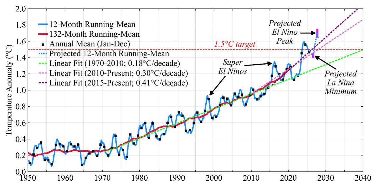
Fig. 1. Global surface temperature (relative to 1880-1920 base period).¹
Another El Nino Already? What Can We Learn from It?
06 February 2026
James Hansen, Pushker Kharecha, Dylan Morgan and Jasen Vest
Abstract. The world seems headed into another El Nino, just 3 years after the last one. Such quick return normally would imply, at most, an El Nino of moderate strength, but we suggest that even a moderately strong El Nino may yield record global temperature already in 2026 and still greater temperature in 2027. The extreme warming will be a result mainly of high climate sensitivity and a recent increase of the net global climate forcing, not the result of an exceptional El Nino, per se. We find that the principal drive for global warming acceleration began in about 2015, which implies that 2°C global warming is likely to be reached in the 2030s, not at midcentury.
It is important to understand ongoing global temperature change as well and as soon as possible for the sake of policy assessment. As a first step for discussion, let us clarify what is shown by the blue curve in Fig. 1: it is the 12-month running-mean of the global temperature anomaly relative to base period 1880-1920 (the earliest time with data adequate for a reliable multi-decade global mean). Black squares in the blue curve indicate the annual mean (Jan-Dec) temperature.
Researchers often show annual temperatures connected by straight lines, as in Fig. 2.² If the blue curve in Fig. 1 is replaced by straight lines connecting the black squares, our graph becomes Fig. 2. We prefer³ the 12-month running-mean, which takes out noise and seasonality of temperature change at any time of year; no need to wait until December. The higher temporal resolution of the running-mean provides more information, e.g., in studying the global temperature response to a volcano, which may occur in any month with a climate effect of limited duration.
El Nino. The El Nino/La Nina cycle is the main cause of global temperature oscillation in Fig.1. During the more persistent La Nina phase, easterly (east-to-west) trade winds in the equatorial Pacific push warm surface water toward the western Pacific, causing upwelling of cold deepwater near South America. Atmospheric circulation engendered by this ocean temperature
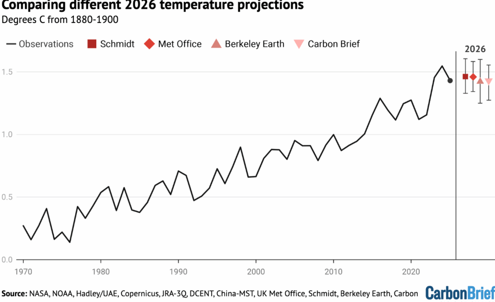
Fig. 2. Multi-analysis-mean global temperature for 1970-2025 and projections for 2026.
pattern reinforces the trade winds and helps perpetuate the temperature pattern (UK Met Office video). This reinforcement (Bjerknes feedback) can temporarily work in the opposite sense and spur an El Nino, if westerly wind bursts cause sufficient eastward movement of warm water. However, many factors including the initial ocean state, the phase of natural (Madden-Julian) atmospheric disturbances, the fickle wind bursts, even salinity anomalies in surface waters,⁴ make the occurrence and magnitude of El Ninos difficult to predict.⁵ ⁶
…
1 replies
 = new reply since forum marked as read
Highlight:
NoneDon't highlight anything
5 newestHighlight 5 most recent replies
= new reply since forum marked as read
Highlight:
NoneDon't highlight anything
5 newestHighlight 5 most recent replies
= new reply since forum marked as read
Highlight:
NoneDon't highlight anything
5 newestHighlight 5 most recent replies
Another El Nino Already? What Can We Learn from It? -- James Hansen, et al. (Original Post)
OKIsItJustMe
2 hrs ago
OP

BumRushDaShow
(167,089 posts)1. The past 4 or so years
we have been in a La Nina and/or Neutral ENSO. It's been awhile since we had an El Nino.