The historic severe storm that hit Houston/Harris County has now been designated a "derecho" wind storm. [View all]
I have learned a new term. This storm continued long after it left Houston
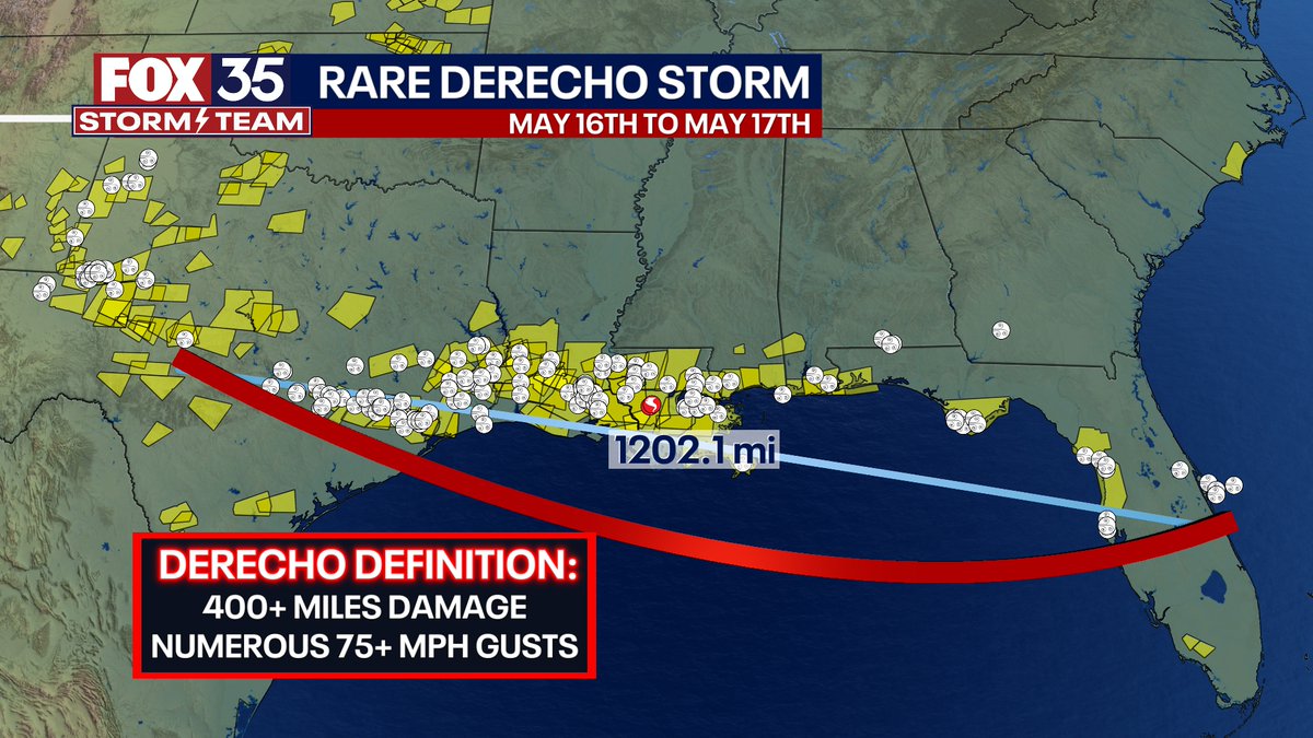
Some big weather news today, the historic severe storm that started in Texas and ended in central Florida Thursday evening into Friday midday has now been designated a "derecho" wind storm. Early damage estimates are several BILLION dollars just in Houston, Texas alone. It started in Texas and ended in Florida, but the majority of the damage was in Texas, Louisiana, and the Florida Panhandle. I also plotted the Severe Storm Warnings that occurred and each icon a severe wind report.
These are what often happen in the Heartland and northern United States in the summer when they ride the periphery of a "heat dome" -- just like this one did.
I looked up this term and found this
https://www.cnn.com/2023/02/27/weather/derecho-damaging-wind-event-xpn/index.html
A derecho is a significant, potentially destructive weather event that is characterized as having widespread, long-lived, straight-line winds associated with a fast-moving group of severe thunderstorms.
Here’s what you need to know about derechos:
They can produce hurricane-force winds
While there’s no official or universal definition for a derecho, it is classified by a swath of wind damage extending more than 400 miles with wind gusts of 58 mph or greater along most of its length, according to the Storm Prediction Center.
The SPC increased the required path of damage by more than 50% from 240 miles to 400 miles in January 2022 based on a 2016 study. The hope was that the added rigor would help reserve the term “derecho” for the most impactful, long-lasting and widespread events, SPC meteorologists told CNN.
“We’re really trying to highlight with just one word, the worst, most damaging wind event that you can potentially expect,” Matt Elliott, SPC warning coordination meteorologist, told CNN. “If we can keep it to these higher end events, then it can be really meaningful because when you hear that term it’s means that we’re talking about something extremely serious.”,....
They’re one of the costliest severe storms
Winds within a derecho can be as strong as a tornado, knocking out trees, powerlines, mobile homes, barns and other similar structures, according to the Storm Prediction Center.
They are most dangerous to those outdoors, whether in a rural or urban area. However, cities are particularly vulnerable to these high winds due to damage to electrical and communication lines, falling trees, and damage to buildings.
The weather people kept mentioning this type of storm on the local coverage and I had to look it up and learned more about this type of storm
 = new reply since forum marked as read